Wetting of a dry soil
Content
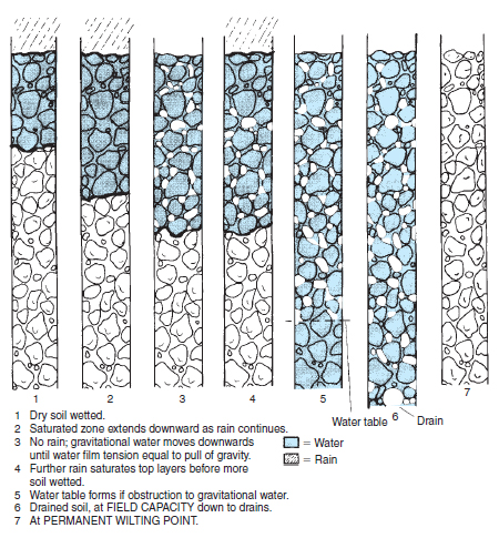
Rainfall is recorded with a rain gauge (see Figure 2.13) and is measured in millimetres of water. Thus ‘1 mm of rain’ is the amount of water covering any area to a depth of 1 mm. Therefore ‘1 mm of rain’ on one hectare of land is equivalent to 10 m 3 or 10 000 litres of water per hectare (area 10 000 m2 × depth 0.001 m). As rain falls on a dry surface the water either soaks in (infiltration) or runs off over the surface as surface run-off. Accumulation of water on the surface (ponding) is a result of infiltration rates slower than rainfall. Ponding leads to soil capping, which further reduces infiltration rates. Soil surfaces can be protected with mulches and care should be taken with water application rates during irrigation. Saturated soils As water soaks into the dry soil, air is forced out of the surface layers which become saturated (waterlogged). As water continues to enter the soil it moves steadily downwards, with a sharp boundary between the saturated zone and the dry, air-filled layers, as shown in Figure 19.2. So long as water continues to soak into the soil, this wetting front moves to greater depths and air is forced out of this zone.
As the volume of water decreases, its surface area and hence its surface tension becomes proportionally greater until, in very thin films of water, it prevents the reduced volume of water from being removed by gravity. A useful comparison can be seen when your hands are lifted from a bowl of water. They drip until the forces in the surface of the thin film become equal to the forces of gravity acting on the remaining small volume of water over the hands. Field capacity (FC) As gravitational water (sometimes referred to as ‘excess water’) is removed, air returns in its place. On sandy soils this may take a matter of hours after the rain has stopped, but may take far longer on clay where the process may continue for many days. The soil is then said to be at field capacity (FC). More precisely, it is a soil that has been saturated, then allowed to drain freely without evaporation until drainage effectively ceases. In practice it is assessed after two days. At field capacity the micropores (those less than about 0.05 mm diameter) remain full of water; whereas in the macropores (greater than about 0.05 mm) air replaces the gravitational water, as illustrated in Figure 19.3. The air expelled has been replaced by ‘fresh’ air which is higher in oxygen and lower in carbon dioxide content. The amount of water held at field capacity is known as the waterholding capacity ( WHC) or moisture-holding capacity (MHC). Examples are given in Table 19.1 The WHC is expressed in millimetres of water for a given depth of soil. Thus a silty loam soil 300 mm deep holds 65 mm of water when at field capacity. Conversely, if a silty loam had become completely dry to 300 mm depth, it would require 65 mm of rain or irrigation water to return it to field capacity; about an average month’s rainfall in many parts of the British Isles. Since 1 mm of water is equivalent to 10m3/ha, a hectare of silty loam would hold 650 m3 water in the top 300 mm when at field capacity. The principle described enables water-holding capacity or irrigation requirement to be determined for any soil depth. The amount of water required to return a soil to field capacity is called the soil moisture deficit (SMD).
Water tables Groundwater occurs where the soil and underlying parent material are saturated (see Figure 19.3) and the water table marks the top of this saturated zone, which fl uctuates over the seasons, normally being much higher in winter. In wetlands the water table is very near the soil surface and the land is not suitable for horticulture until the water table of the whole area is lowered (see drainage). Where water fl ows down the soil profile and is impeded by an impermeable layer, such as saturated clay or silty clay, a perched (or crown) water table is formed. Water from above cannot drain through the impermeable barrier and so a saturated zone builds up above it. Springs appear at a point on the landscape where an overlying porous material meets an impermeable layer at the soil surface, e.g. where chalk hills or gravel mounds overlie clay. Capillary rise Water is drawn upwards from the water table through a continuous network of pores. The height to which water will rise and the rate of movement depends on the continuity of pores and their diameter. In practice the rise from the water table is rarely more than 2 cm for coarse sands, typically 15 cm in finer textured soils, but it can be substantially greater in silty soils and in chalk. The upward movement of water in these very fine pores is very slow. Capillary rise is used to aid the watering of plants grown in containers (see capillary benches). Several ‘self-watering’ containers also depend on capillary rise from a water store in their base (see aggregate culture). |
|||||||||||||||||||||||||||
Support our developers