Climate of the British Isles
ContentThe British Isles has a maritime climate, characterized by mild winters and relatively cool summers, which is a consequence of its proximity to the sea. This is because water has a much larger heat capacity than materials making up the land. As a consequence, it takes more heat energy to raise the temperature of water one degree, and there is more heat energy to give up when the water cools by one degree, when compared with rock and soil. Consequently bodies of water warm up and cool down more slowly than adjoining land. The nearby sea thus prevents coastal areas becoming as cold in the winter as inland areas and also helps maintain temperatures well into the autumn. In contrast, inland areas on the great landmasses at the same latitude have a more extreme climate, with very cold winters and hot summers; the features of a continental climate. Whereas most of the British Isles lowland is normally above freezing for most of the winter, average mid-winter temperatures for Moscow and Hudson Bay (both continental climate situations) are nearer −15°C.
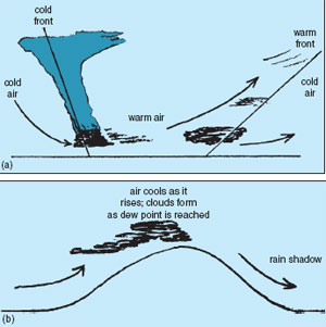
The mixing of this warm moist air stream and the cold air masses over the rest of the Atlantic leads to the formation of a succession of depressions. These regularly pass over the British Isles bringing the characteristic unsettled weather; with clouds and rain where cold air meets the moist warm air in the slowly swirling air mass. Furthermore, the moist air is also cooled as it is forced to rise over the hills to the west of the islands giving rise to orographic rain. In both instances clouds form when the dew point is reached. This leads to much higher rainfall levels in the west and north compared with the south and east of the British Isles. In contrast, a rain shadow is created on the opposite side of the hills because, once the air has lost water vapour and falls to lower warmer levels, there is less likelihood of the dew point being reached again (see Figure 2.6). Depressions are also associated with windier weather. The sequence of depressions (low-pressure areas) is displaced from time to time by the development of high-pressure areas (anti-cyclones). These usually bring periods of settled drier weather. In the summer these are associated with hotter weather with air drawn in from the hot European land mass or North Africa. In the winter, clear cold weather occurs as air is drawn in from the very cold, dry continental landmass. In the spring, these anti-cyclones often lead to radiation frosts, which are damaging to young plants and top fruit blossom. |
Support our developers